File:Arizona Wildlife Management Units.svg
From Wikimedia Commons, the free media repository

Size of this preview: 517 × 599 pixels. Other resolutions: 207 × 240 pixels | 414 × 480 pixels | 518 × 600 pixels | 663 × 768 pixels | 883 × 1,024 pixels.
Original file (SVG file, nominally 5,462 × 6,331 pixels, file size: 430 KB)
| Description |
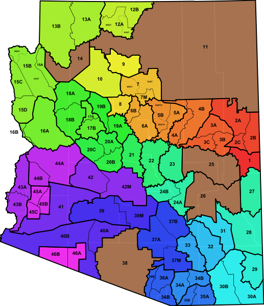
An SVG map of Arizona showing the 46 wildlife management units. The units are semi-transparent so that county boundaries can be visualized. Note that units 11, 14, 25, 26, and 38 are Indian Reservations and thus are not managed by the Bureau of Land Management or by the Arizona Game and Fish Department. Data from the Bureau of Land Management. See also the Arizona Game and Fish Department. |
| Date | (UTC) |
| Source | |
| Author |
|
|
I, the copyright holder of this work, hereby publish it under the following license:
|
Original upload log[edit]
This image is a derivative work of the following images:
- File:Blank_Map_of_Arizona.svg licensed with PD-self
- 2011-04-03T04:19:21Z Ninjatacoshell 5462x6331 (60585 Bytes) {{Information |Description=A blank SVG map of Arizona showing the 15 counties. |Source=*[[:File:Map_of_Arizona_highlighting_Coconino_County.svg|]] |Date=2011-04-03 04:16 (UTC) |Author=*[[:File:Map_of_Arizona_highlighting_Coco
Uploaded with derivativeFX
File history
Click on a date/time to view the file as it appeared at that time.
| Date/Time | Thumbnail | Dimensions | User | Comment | |
|---|---|---|---|---|---|
| current | 05:18, 3 April 2011 | | 5,462 × 6,331 (430 KB) | Ninjatacoshell (talk | contribs) | {{Information |Description=An SVG map of Arizona showing the 46 wildlife management units. The units are semi-transparent so that county boundaries can be visualized. Note that units 11, 14, 25, 26, and 38 are Indian Reservations and thus are not managed |
- You cannot overwrite this file.
File usage on Commons
The following page links to this file: