File:Compass Card.png
From Wikimedia Commons, the free media repository

No higher resolution available.
Compass_Card.png (593 × 593 pixels, file size: 165 KB, MIME type: image/png)
L==Summary==
| Description |
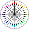
This is my own rendering of what a modern compass card can look like. Compass headings are denoted on this compass card by different colours. If you are thinking of converting this to SVG, you need to have a lot of patience, as this image uses a conical gradient, which is not supported by the SVG 1.1 specification. |
| Date | |
| Source | Own work |
| Author | Denelson83 |
| Other versions |
|
|
I, the copyright holder of this work, hereby publish it under the following licenses:
You may select the license of your choice.
|

File history
Click on a date/time to view the file as it appeared at that time.
| Date/Time | Thumbnail | Dimensions | User | Comment | |
|---|---|---|---|---|---|
| current | 07:54, 16 September 2010 | | 593 × 593 (165 KB) | Trockennasenaffe (talk | contribs) | optimized with OptiPNG |
| 03:34, 8 May 2005 |  | 593 × 593 (213 KB) | Denelson83 (talk | contribs) | This is my own rendering of what a modern compass card can look like. Compass headings are denoted on this compass card by different colours. {{GFDL-self}} |
- You cannot overwrite this file.
File usage on Commons
The following 37 pages link to this file:
- Compass
- User:Duch.seb
- User:Gonioul
- User:JDavid
- User:Jejecam
- User:Mike bzh
- User:Myrabella
- User:Nichalp/Upload script/csv fields
- User:Pulsar.co.nr/badge/Geotag
- User:Qyd/sandbox
- User:Reneman
- User:ShakespeareFan00/Sandbox/Commons Geocode Rewrite
- User:Sémhur/Brouillon
- User:Unai Fdz. de Betoño
- User:Vantey
- User:~Pyb/Brouillon
- User talk:Para/2008-08-08
- Commons:Bistro/archives/mai 2008
- Commons:Coğrafi Kodlama
- Commons:Geocoding
- Commons:Geocoding/Panorama
- Commons:Geocoding/ro
- Commons:Geokodowanie
- Commons:Geokoodaus
- Commons:Geolocalización
- Commons:Georeferenziazione
- Commons:Georeferenzierung
- Commons:Georreferenciação
- Commons:Géolocalisation
- Commons:Souřadnicování
- Commons:ജിയോകോഡിങ്
- Commons:地理编码工程
- File:Compass Card.svg
- File:Compass Card B+W.svg
- File:Compass Card Modified.jpg
- File:Compass Card transparent.png
- Template:Location/general documentation
File usage on other wikis
The following other wikis use this file:
- Usage on ar.wikipedia.org
- Usage on de.wikipedia.org
- Usage on de.wiktionary.org
- Usage on en.wikipedia.org
- Points of the compass
- Kastellaun
- Kleinwallstadt
- Niedernberg
- Alterkülz
- Bell, Rhein-Hunsrück
- Beltheim
- Buch, Rhein-Hunsrück
- Dickenschied
- Dill, Germany
- Dillendorf
- Fronhofen
- Gödenroth
- Hahn, Rhineland-Palatinate
- Hecken
- Holzbach
- Kappel, Rhineland-Palatinate
- Keidelheim
- Kirchberg, Rhein-Hunsrück
- Michelbach, Rhein-Hunsrück
- Hasselbach, Rhein-Hunsrück
- Riesweiler
- Wahlbach
- Womrath
- Woppenroth
- Wüschheim
- Perscheid
- Tiefenbach, Rhineland-Palatinate
- Spesenroth
- Sohrschied
- Kümbdchen
- Laubach, Rhein-Hunsrück
- Lautzenhausen
- Lindenschied
- Mengerschied
- Mastershausen
- Neuerkirch
- Sargenroth
- Reich, Germany
- User talk:AgnosticPreachersKid/Archive 16
- User:Jaa101/sandbox
- Usage on en.wikiquote.org
- Usage on en.wiktionary.org
View more global usage of this file.