File:Sri Lanka Naval Areas of Operations.svg
From Wikimedia Commons, the free media repository

Size of this preview: 391 × 599 pixels. Other resolutions: 157 × 240 pixels | 313 × 480 pixels | 392 × 600 pixels | 501 × 768 pixels | 668 × 1,024 pixels.
Original file (SVG file, nominally 1,200 × 1,838 pixels, file size: 97 KB)
| Description |
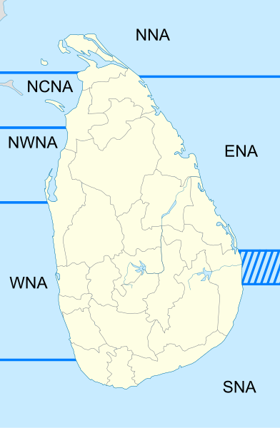
A map of Sri Lanka showing the Naval Areas of Operations as designated by the Sri Lankan Navy. |
| Date | (UTC) |
| Source | |
| Author |
|
|
I, the copyright holder of this work, hereby publish it under the following licenses:
You may select the license of your choice.
|

Original upload log[edit]
This image is a derivative work of the following images:
- File:Sri_Lanka_location_map.svg licensed with Cc-by-sa-3.0, GFDL
- 2010-02-18T13:06:36Z Uwe Dedering 1200x1838 (173091 Bytes) {{Information |Description={{en|1=Location map of Sri Lanka. Equirectangular projection. Strechted by 101.0%. Geographic limits of the map: * N: 10.2° N * S: 5.5° N * W: 79.2° E * E: 82.3° E Made with Natural Earth.
Uploaded with derivativeFX
File history
Click on a date/time to view the file as it appeared at that time.
| Date/Time | Thumbnail | Dimensions | User | Comment | |
|---|---|---|---|---|---|
| current | 00:31, 30 March 2011 | | 1,200 × 1,838 (97 KB) | Ninjatacoshell (talk | contribs) | Converted text to shapes. |
| 00:30, 30 March 2011 |  | 1,200 × 1,838 (88 KB) | Ninjatacoshell (talk | contribs) | I removed distracting colors and replaced with lines. I also added acronym labels for each of the areas. | |
| 17:33, 28 March 2011 |  | 1,200 × 1,838 (84 KB) | Ninjatacoshell (talk | contribs) | {{Information |Description=A map of Sri Lanka showing the Naval Areas of Operations as designated by the Sri Lankan Navy.<br><br><table border="0" cellspacing="0" cellpadding="1" style="background:transparent"> <tr valign="top"><td> {{Legend|#FF0000|'''No |
- You cannot overwrite this file.
File usage on Commons
The following page links to this file:
File usage on other wikis
The following other wikis use this file:
- Usage on en.wikipedia.org