File:US Great Plains Map.svg
From Wikimedia Commons, the free media repository

Size of this preview: 800 × 495 pixels. Other resolutions: 320 × 198 pixels | 640 × 396 pixels | 1,024 × 633 pixels | 1,280 × 791 pixels.
Original file (SVG file, nominally 959 × 593 pixels, file size: 87 KB)
| Description |
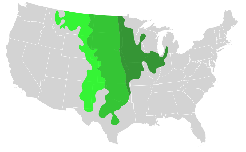
Biogeographical map of the Great Plains.
Transparency is enabled so that state borders can still be discerned.
|
|
| Date | (UTC) | |
| Source | ||
| Author |
|
I, the copyright holder of this work, hereby publish it under the following licenses:
You may select the license of your choice.
|

Original upload log[edit]
This image is a derivative work of the following images:
- File:Blank_US_Map.svg licensed with Cc-by-sa-3.0-migrated, GFDL
- 2009-11-05T19:44:02Z NuclearVacuum 959x593 (91518 Bytes) minor fix from previous upload
- 2009-11-05T19:39:42Z NuclearVacuum 959x593 (88399 Bytes) Fixed up the borders so they are connected with each state and loosing that gap between them.
- 2008-10-09T16:36:40Z Howcheng 959x593 (80121 Bytes) Reverted to version as of 08:32, 14 June 2007
- 2008-03-12T00:20:02Z AMK1211 959x593 (174744 Bytes) Added borders: Light blue for water borders and black for land borders (international borders thicker).
- 2007-06-14T08:32:47Z Fibonacci 959x593 (80121 Bytes) Optimised code.
- 2006-07-12T23:00:30Z Theshibboleth 959x593 (90537 Bytes) The line framework around Alaska and Hawaii has been pushed a bit
- 2006-07-12T06:35:19Z Theshibboleth 959x593 (89828 Bytes) added DC
- 2006-07-12T06:05:05Z Theshibboleth 959x593 (89649 Bytes) {{Information |Description=A blank map of the United States in scalable vector form. |Source=Own work, based on [[:Image:Electorial map.svg]], inspired by [[:Image:BlankMap-World.png]] |Date=11 July 2006 |Author=[[User:Theshi
Uploaded with derivativeFX
File history
Click on a date/time to view the file as it appeared at that time.
| Date/Time | Thumbnail | Dimensions | User | Comment | |
|---|---|---|---|---|---|
| current | 22:39, 18 March 2011 | | 959 × 593 (87 KB) | Ninjatacoshell (talk | contribs) | {{Information |Description=A map showing the different grassland regions of the Great Plains region of the United States. Data from a display at Brigham Young University's Bean museum.<br><br><table border="0" cellspacing="0" cellpadding="1" style="backgr |
- You cannot overwrite this file.
File usage on Commons
The following page links to this file:
File usage on other wikis
The following other wikis use this file:
- Usage on bg.wikipedia.org
- Usage on de.wikipedia.org
- Usage on en.wikipedia.org
- Usage on es.wikipedia.org
- Usage on es.wikibooks.org
- Usage on fy.wikipedia.org
- Usage on hu.wikipedia.org
- Usage on ja.wikipedia.org
- Usage on la.wikipedia.org
- Usage on nl.wikipedia.org
- Usage on pl.wikipedia.org
- Usage on sv.wikipedia.org