File:US Wetlands.svg
From Wikimedia Commons, the free media repository

Size of this preview: 800 × 495 pixels. Other resolutions: 320 × 198 pixels | 640 × 396 pixels | 1,024 × 633 pixels | 1,280 × 791 pixels.
Original file (SVG file, nominally 959 × 593 pixels, file size: 841 KB)
| Description |
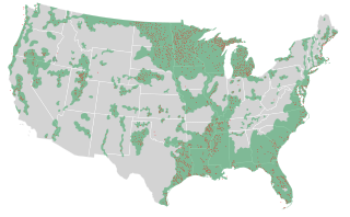
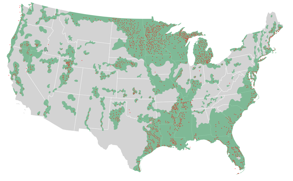
A map of the United States showing the location of major remaining wetlands (green) and the location of specific sites that are critical for habitat and reproduction of wildlife (red dots). Data from a display at Brigham Young University's Bean Museum. |
| Date | (UTC) |
| Source | |
| Author |
|
|
I, the copyright holder of this work, hereby publish it under the following licenses:
You may select the license of your choice.
|

Original upload log[edit]
This image is a derivative work of the following images:
- File:Blank_US_Map.svg licensed with Cc-by-sa-3.0-migrated, GFDL
- 2009-11-05T19:44:02Z NuclearVacuum 959x593 (91518 Bytes) minor fix from previous upload
- 2009-11-05T19:39:42Z NuclearVacuum 959x593 (88399 Bytes) Fixed up the borders so they are connected with each state and loosing that gap between them.
- 2008-10-09T16:36:40Z Howcheng 959x593 (80121 Bytes) Reverted to version as of 08:32, 14 June 2007
- 2008-03-12T00:20:02Z AMK1211 959x593 (174744 Bytes) Added borders: Light blue for water borders and black for land borders (international borders thicker).
- 2007-06-14T08:32:47Z Fibonacci 959x593 (80121 Bytes) Optimised code.
- 2006-07-12T23:00:30Z Theshibboleth 959x593 (90537 Bytes) The line framework around Alaska and Hawaii has been pushed a bit
- 2006-07-12T06:35:19Z Theshibboleth 959x593 (89828 Bytes) added DC
- 2006-07-12T06:05:05Z Theshibboleth 959x593 (89649 Bytes) {{Information |Description=A blank map of the United States in scalable vector form. |Source=Own work, based on [[:Image:Electorial map.svg]], inspired by [[:Image:BlankMap-World.png]] |Date=11 July 2006 |Author=[[User:Theshi
Uploaded with derivativeFX
File history
Click on a date/time to view the file as it appeared at that time.
| Date/Time | Thumbnail | Dimensions | User | Comment | |
|---|---|---|---|---|---|
| current | 18:16, 21 March 2011 | | 959 × 593 (841 KB) | Ninjatacoshell (talk | contribs) | {{Information |Description=A map of the United States showing the location of major remaining wetlands (green) and the location of specific sites that are critical for habitat and reproduction of wildlife. Data from a display at Brigham Young University's |
- You cannot overwrite this file.
File usage on Commons
The following page links to this file:
File usage on other wikis
The following other wikis use this file:
- Usage on en.wikipedia.org